We usually celebrate when a summer cold front rolls into the American West. It means relief from a brutal heatwave, right? Wrong. In the fire world, a summer cold front is often a death sentence for forests and a nightmare for fire crews. Instead of cool rain, these systems frequently deliver a double blow of dry lightning and erratic winds that can transform a small, smoldering ember into a massive inferno within minutes.
When weather forecasters scream about high fire danger, people look at the thermometer. If it isn't 100 degrees out, they think they're safe. But fire meteorology doesn't care about sheer heat alone. The combination of parched vegetation, sudden wind shifts, and dry thunderstorms creates a volatile mixture that catches communities completely flat-footed.
Let's pull back the curtain on how these specific systems operate, why our current mental models of fire risk are broken, and what you actually need to do to survive when this specific weather hits your area.
The Atmospheric Double Team That Lights the West
Most people understand that drought dries out trees and brush, turning them into fuel. What people miss is the exact trigger mechanism that turns dry brush into an active emergency. That trigger is almost always an upper-level weather disturbance or a dry cold front.
When a cold front moves over the mountain ranges of California, Oregon, or Washington, it pushes into a pre-existing layer of intense desert heat. This interaction does two incredibly dangerous things at the exact same time: it builds dry thunderstorms and brings fierce, shifting winds.
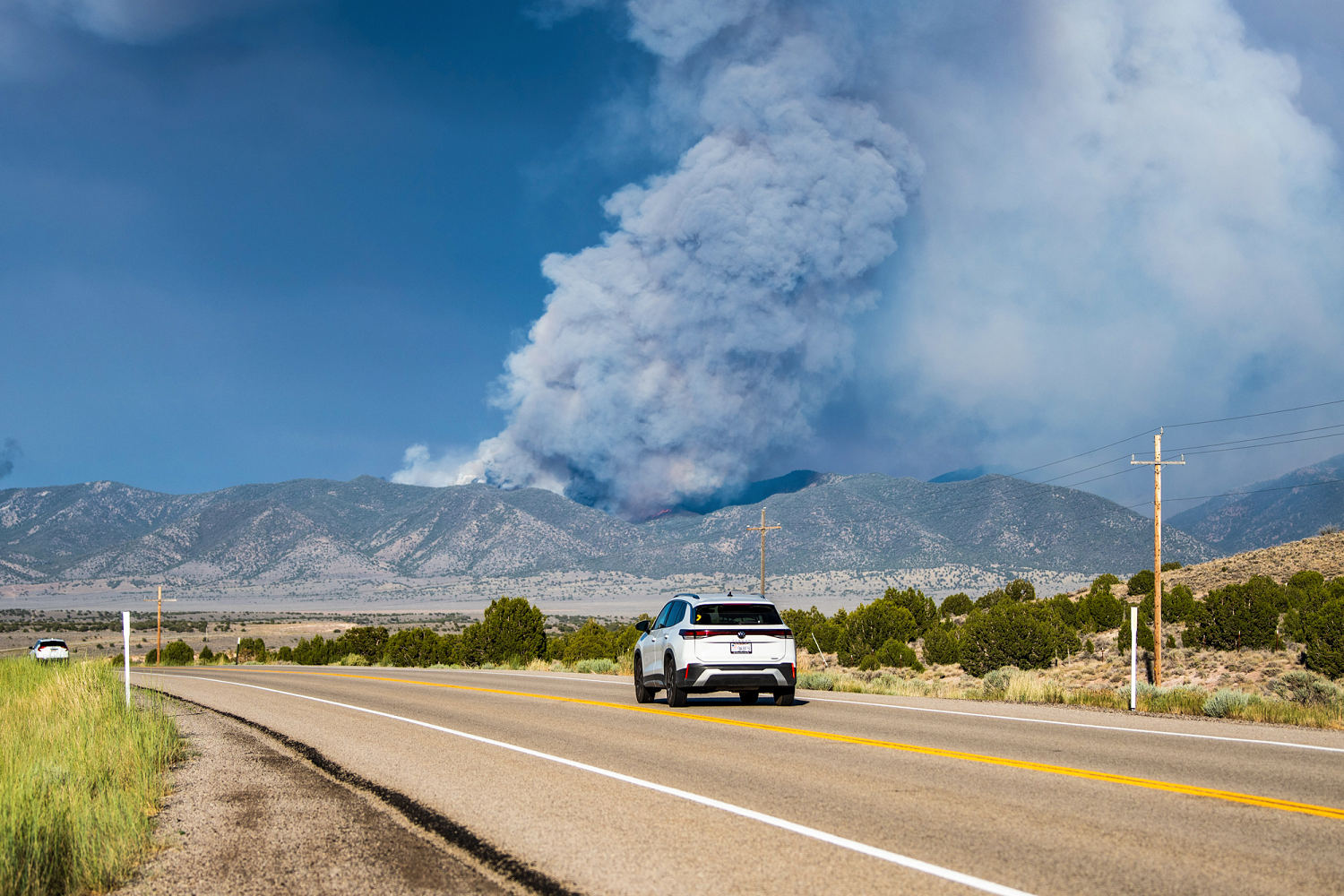
Dry lightning happens because the lower layer of the atmosphere is so dry that any rain produced by a thunderstorm evaporates before it ever touches the grass. This is called virga. You can see it from miles away—dark streaks hanging from clouds that disappear mid-air. The lightning still reaches the ground, striking dry pine needles or grass, but there's no water to put out the spark.
While that new spark is catching, the cold front introduces a sudden shift in wind direction. If a fire was moving slowly to the north under a light southern breeze, the frontal passage might suddenly blast air from the northwest at 40 miles per hour. Suddenly, the long, thin side flank of the fire becomes a massive, fast-moving wall of flames moving in a completely new direction. This is exactly how firefighters get trapped and how towns get cut off from evacuation routes.
The Three Stages of Ridge Breakdown
Fire crews don't just look at the daily forecast. They watch a multi-day atmospheric dance called the breakdown of the upper ridge. An upper ridge is basically a giant dome of high pressure that traps hot, stagnant air over a region. When a cold front or low-pressure system approaches to break that dome, it happens in three distinct stages that dictate fire behavior.
First comes the thermal squeeze. As the high pressure starts to crack, the weather gets even hotter and drier. Relative humidity drops into the single digits, making the fuel incredibly sensitive to any ignition.
Second is the wind ramp. Before the actual front arrives, the atmospheric pressure gradient tightens. Winds begin to howl across ridge lines, pulling bone-dry air across valleys. This is the phase where most catastrophic fire growth occurs. Existing fires spot miles ahead because the wind carries embers deep into unburned territory.
Third is the frontal hammer. The cold front finally cuts through. This is when the dry lightning strikes and the wind direction flips completely. The temperature drops, sure, but the air remains dry enough that it doesn't slow down the flames. The rapid shifting of the wind creates chaos on the ground.
What Everyone Gets Wrong About Red Flag Warnings
If you live in a fire-prone area, you've probably seen a Red Flag Warning pop up on your phone. Most people treat it like a generic rain forecast and ignore it. That is a massive mistake.
A Red Flag Warning isn't just saying it's dry outside. It means conditions are ideal for extreme fire behavior, which means fires that create their own weather, run faster than you can drive, and ignore traditional containment tactics.
People assume that if a fire starts during a warning, local fire departments will just drive out and put it out. They don't realize how dry lightning works. A single thunderstorm system can produce hundreds of lightning strikes in an hour, igniting dozens of fires simultaneously across remote mountain terrain. Resources get stretched so thin within the first thirty minutes that nobody is coming to save individual homes. You are your own first responder during these events.
Another common misconception is that living in a suburban neighborhood clears you of risk. Embers don't care about property lines. During high-wind frontal events, wind-driven embers act like a blizzard of fire, traveling over a mile ahead of the main fire front. They land in plastic gutters, under wooden decks, and inside attic vents. Your house can burn down before the forest fire even gets close.
Hard Truths About Home Survival in High Winds
Defensible space sounds great on paper, but standard clearing methods often fail during a combination of wind and lightning. Cutting down a few bushes isn't enough when sixty-mile-per-hour gusts are throwing hot coals directly at your house.
If you want your property to survive a fast-moving, wind-driven fire event, you have to look at the immediate five-foot zone around your foundation. This is what fire scientists call the non-combustible zone. If you have wood mulch, dry grass, or woody shrubs touching your siding, an ember will find it, ignite it, and burn your house from the outside in. Replace mulch with crushed rock or gravel. Remove any plants that sit directly under windows.
Look at your vents. Standard attic and crawlspace vents are basically open doors for embers. When a cold front brings high winds, it forces embers through those wire meshes right into your insulation. Upgrading to ember-resistant vents that block radiant heat and flying sparks is one of the single most effective retrofits you can make.
Your Immediate Survival Plan When the Front Approaches
When forecasters warn of approaching lightning and wind, you need to change your behavior immediately. Stop waiting for an official evacuation order to start packing your bags. By the time the sheriff knocks on your door, smoke will be blinding, roads will be congested, and panic will set in.
Create a hard trigger point for your family. Decide right now that if a fire starts within a specific radius of your home during a Red Flag Warning, you leave instantly. Don't look for more information on social media. Don't pack the car when you see flames. Pack it the night before the front hits.
Keep your car parked facing out of your driveway with the garage door opener in the vehicle. If the power goes out—which happens frequently when high winds knock down power lines or utilities initiate public safety power shutoffs—you need to know how to open your garage door manually. Practice pulling that red emergency cord and lifting the door yourself so you don't get trapped inside your own home.
Clear any outdoor furniture cushions, plastic toys, and firewood piles away from your house structure. Move them into the garage or throw them out into the open yard away from the building. Turn off your air conditioning units before you leave so they don't suck heavy smoke and embers into your living space.
Monitor regional weather updates using a dedicated NOAA weather radio or trusted local meteorological feeds rather than relying solely on cellular networks, which can fail under mass evacuation stress or infrastructure damage. When the atmosphere primes itself for a blowout, minutes save lives. Do not waste them waiting for permission to protect yourself.